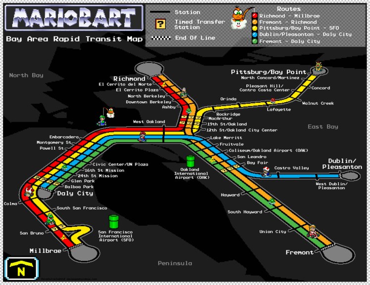
Now available as a high-res poster you can purchase here.
Yesterday I posted a work-in-progress (since deleted) of this map, and now I am happy to report I completed it. Was able to get the right pixel look I wanted for the track, making it look rendered by the SNES’ Mode 7. I also substituted the Blooper fishes for warp pipes, and added cul-de-sacs to the end of the tracks to undercut their ‘dead end’ nature.
To reiterate, this BART map is based on the Rainbow Road track from Mario Kart (SNES), which is why the terrain is dark. However I see a lot of transit maps using this look for the background, so it works pretty well if I may say so.


I’d buy this poster in a heartbeat.
I second that. Want! Nice work.
Done! Link is in the post.
Can I have permission to bomb the fremont station with printout of these?! 😀
Sorry I cannot condone vandalism using my art — might get me into hot water! However I’d be more than happy to help the BART overlords if they’d like to post these at stations.
How are you gonna fit in Warm Springs and Irvington? 😛
I can add extensions later (I already do with my other maps). With this map the track is like a 3D model, so I can zoom the camera out more to fit in additional track. Looks like updates aren’t needed for 3 more years.
I’m just messing with you 😛 Excellent job! I’m considering buying a print!
*looks at 2012 date on this comment* Well, more than three years out from that now, eh? I suppose ground must have been broken by now if they were ever going to make a late 2017 target (I haven’t really been over in that area to look), but partly due to decreased gas tax revenue lately, the timeline may have to be extended yet again.
This is sweet! Now someone will just have to build it for SuperTuxKart. would need an extra track Pittsburgh-Pleasanton to complete the loop.
This has utterly warmed my cold commuter heart. Well done!